
With five hurricane categories to understand, warnings and watches to untangle, and the confusing math of what storm surge is, hurricanes can be a mystery. So, with the first major hurricane of the season churning up the Gulf of Mexico, the disaster responders at Team Rubicon offer an explainer of some of the most important things to understand about hurricanes.
Hurricane vs. Typhoon
Hurricanes and typhoons are one and the same. When a tropical cyclone exceeds 74 mph in the Atlantic or East Pacific Oceans, it is called a hurricane. When a tropical cyclone exceeds 74 mph in the West Pacific Oceans, it is called a typhoon.
For example, in 2022, Hurricane Ian came off the Atlantic and up the Gulf of Mexico and struck the U.S. Southeast in Florida, while Typhoon Merbok spun up in the Pacific Ocean and struck Alaska.
In October of 2025, the remnants of Typhoon Halong smashed into Alaska, devastating the western Yukon–Kuskokwim Delta, the tundra set between Nome and the Aleutian Islands.
Hurricane Watch vs. Hurricane Warning
A Hurricane Watch is an announcement that hurricane-force winds are possible. It is issued 48 hours in advance of the anticipated onset.
Hurricane Warnings are issued 36 hours in advance and are announced when hurricane-force winds are expected. The warning can remain in effect even if winds drop to below hurricane-force if other hazards, such as intense rainfall or flooding, are possible.
Understand Hurricane Categories and the Saffir-Simpson Scale
The Saffir-Simpson Scale is a classification system for hurricanes, which are also known as tropical cyclones.
The Saffir-Simpson scale breaks hurricanes into five categories based on maximum sustained wind speed—winds that last for an average of at least one minute at the surface of a hurricane, or about 33 feet—with a Category 1 hurricane being the weakest and a Category 5 being the strongest.
Hurricanes that fall into the categories 3, 4, and 5 on the Saffir-Simpson Scale are classified as major hurricanes—also called intense hurricanes. A typhoon that reaches category 4 or 5 on the Saffir-Simpson Scale is a super-typhoon. These are the hurricane categories, their potential impact, and some recent examples.
Category 1 Hurricane: Some Damage
Maximum Sustained Wind Speeds: 74-95 mph
Very dangerous winds will produce some damage, with the possibility of snapping large branches from trees and toppling shallow-rooted trees. Damage to roofs, shingles, vinyl siding, and gutters could occur on well-constructed frame homes. Damage to power lines and poles would likely result in outages that could last a few to several days.
Recent examples: Hurricanes Sandy and Florence
Proof that even Category 1 Hurricanes can be devastating lies in 2012’s Hurricane Sandy, which caused $85.9 billion in damages, and 2018’s Hurricane Florence, which caused $29 billion in damages.
Category 2 Hurricane: Extensive Damage
Maximum Sustained Wind Speeds: 96-110 mph
Extremely dangerous winds will cause extensive damage, with major roofing and siding damage possible to well-constructed frame homes. Roadways will likely be blocked by numerous snapped and uprooted shallowly-rooted trees. Power loss is to be expected, with outages that could last from several days to weeks.
Recent examples: Hurricanes Delta, Sally, Zeta, and Francine
Multiple hurricanes caused massive damage in 2020, including the Category 1 Isaias and Category 4 Hurricane Laura. Category 2 Hurricanes Delta, Sally, and Zeta caused $3.4 billion, $8.5 billion, and $5.1 billion in damages, respectively.
Category 3 Hurricane: Devastating
Maximum Sustained Wind Speeds: 111-129 mph
Devastating damage should be expected, with even well-built frame homes incurring major damage to, or removal of, roofs. Many trees will be snapped or uprooted and cause numerous roads to be blocked. Both the electrical grid and water supply are likely to be damaged, and both may be unavailable for several days to even weeks after the storm passes.
Recent examples: Hurricanes Katrina and Milton
Among the deadliest examples of a Category 3 Hurricane is Hurricane Katrina, which made landfall in 2005 and brought with it incredible storm surge and flooding, and caused $193.8 billion dollars in damage.
In 2024, Hurricane Milton followed quickly on the heels of Hurricane Helene, causing an estimated $34.3 billion in damage in the United Sates, almost exclusively in Florida, according to The NOAA National Centers for Environmental Information.
Category 4 Hurricane: Catastrophic
Maximum Sustained Wind Speeds: 130-156 mph
Most of the area in the path of a Category 4 Hurricane will be uninhabitable for weeks or months.
Catastrophic damage will occur, with even well-built frame homes facing the possibility of sustaining severe damage. Roof structures and even exterior walls may be destroyed. Most trees in the path will be snapped or uprooted, and power poles will be pulled from the ground or blown down. Many residential areas are likely to be isolated by fallen trees and power poles in a catastrophic Category 4 Hurricane, and power outages will last weeks to possibly months.
Recent examples: Hurricanes Harvey, Maria, Laura, Ian, and Helene
In 2017, Hurricane Harvey caused $155 billion in damage, while Hurricane Maria caused $111.6 billion in damage and left Puerto Rico without power for months. In 2020, Hurricane Laura caused $27.2 billion in damage. When Hurricane Ian came ashore on the Gulf Coast of Florida in 2022, it caused $115.2 billion in damage.
In 2024, Hurricane Helene became the second deadliest hurricane in U.S. history. It spawned 33 tornadoes—including the widest on record—damaged or destroyed more than 125,000 housing units in western North Carolina alone, and caused an estimated $225-$250 billion in losses, according to AccuWeather.
Category 5 Hurricane: Catastrophic
Maximum Sustained Wind Speeds: 157 mph or higher
Most of the area impacted by a Category 5 Hurricane will be rendered uninhabitable for weeks or months.
Catastrophic damage will occur throughout the area, with a high percentage of framed homes totally destroyed. Many homes left standing will experience total roof failure and wall collapse. Fallen trees and power poles will isolate residential areas, and power outages will last for weeks to months.
Recent examples: Hurricane Michael arrived as a Category 5 Hurricane in 2018 and caused $30.2 billion dollars in damage.
Understanding What is Storm Surge, and the Difference Between a Storm Surge Warning and a Storm Surge Watch
Storm surge is an abnormal rise in sea level generated by a storm’s winds blowing onshore that accompanies a hurricane or other intense storm and whose height is the difference between the observed level of the sea surface and the level that would have occurred in the absence of the cyclone. Storm surge is typically estimated by subtracting the normal, or predicted, high tide or astronomical tide from the observed storm tide.
A Storm Surge Warning means there is a danger of life-threatening inundation from rising water during the next 36 hours in the indicated locations.
A Storm Surge Watch means there is a possibility of life-threatening inundation from rising water in the indicated locations during the next 48 hours.
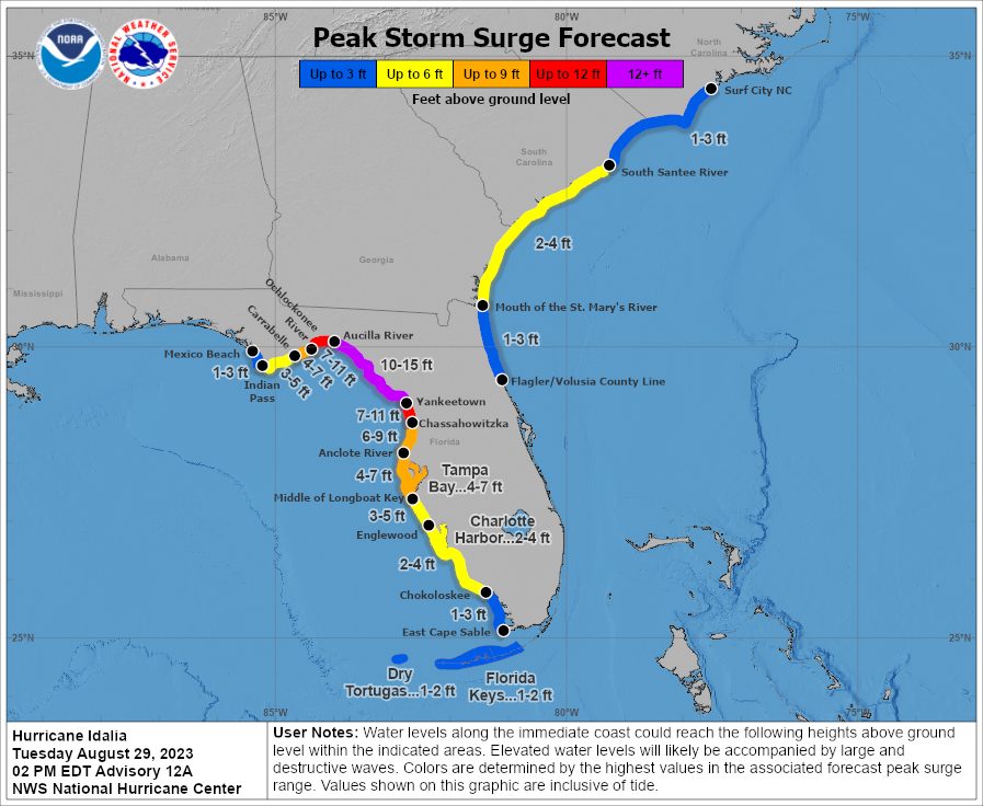
The National Hurricane Center issues public advisories every few hours during a hurricane, including storm surge warnings and projected storm surge levels. For example, as Hurricane Idalia approached on August 29, 2023, the NHC’s 2 p.m. EDT advisory issued storm surge warnings—meaning there is a danger of life-threatening inundation—for several areas and predicted life-threatening storm surge between Aucilla River, FL, and Yankeetown, FL, of 10 to 15 feet.
Elevated Storm Surge: Potential inundation 1 to 3 feet above ground with limited storm surge flooding impacts.
Moderate Storm Surge: Potential inundation 3 to 6 feet above ground with significant storm surge flooding impacts.
High Storm Surge: Potential inundation 6 to 9 feet above ground and extensive storm surge flooding impacts.
Extreme Storm Surge: Potential inundation of 9 feet or greater above ground and devastating to catastrophic storm surge flooding impacts.
Storm surge is also absolutely nothing to be messed with. According to the National Hurricane Center, much of the Atlantic and Gulf Coast coastlines lie less than 10 feet above mean sea level and 27% of major roads within the Gulf Coast region are at or below 4 feet in elevation.


