Another year, another devastating flooding event on the West Coast. Atmospheric river flooding has become one of the most destructive and least understood drivers of disasters in the western United States. Once virtually unheard of outside meteorology circles, atmospheric rivers have inundated the U.S. with increasing frequency over the last several years.
What Is Atmospheric River Flooding?
An atmospheric river is a long, narrow band of concentrated water vapor in the sky. These rivers in the atmosphere act like conveyor belts, transporting enormous volumes of moisture from the tropics toward the West Coast of North America. Although invisible to the eye, an atmospheric river can carry as much water as the Amazon. When that moisture encounters mountains, such as California’s Sierra Nevadas or the Cascades and Olympics of Washington and Oregon, it is forced upward, cooling rapidly and releasing torrents of rain or snow.
While some atmospheric rivers are weak and bring beneficial precipitation. Others—especially when they arrive in a series—can unleash catastrophic impacts. Whether it falls as intense rain or heavy snow that is typically followed by rapid melt, when that moisture hits land—especially mountains, saturated ground, or populated coasts—it often results in extreme runoff, landslides, and coastal or river atmospheric flooding.
Why Atmospheric Rivers Cause Extreme Flooding and Damage
One reason atmospheric rivers can be so devastating is that they deliver enormous amounts of precipitation to a region very quickly. But such disasters also often come as back-to-back storms. If a single atmospheric river event can dump a lot of water on its own, multiple atmospheric rivers in a short period saturate soils, fill reservoirs, and keep rivers high. Once soils are saturated, additional rain runs off immediately, increasing flood peaks and downstream flooding.
Many atmospheric rivers are also embedded in strong extratropical cyclones, which can bring powerful winds that down trees and power lines, coastal storm surge, and warm rain-on-snow events that quickly melt snowpack and send extra water into rivers. Combined effects multiply damage and create extreme atmospheric river flooding.
Such storms also often hit densely populated areas. And while urban drainage, levees, dams, and roads are designed to certain standards, extreme, concentrated rainfall can exceed capacity or cause cascading failures, such as landslides onto roads and levee breaches, producing outsized impacts relative to the rainfall area.
Atmospheric River Flooding in California from Back-to-Back Storms
The worst impacts occur when atmospheric rivers are intense, hit mountains, and/or arrive repeatedly, so the landscape and rivers have no chance to recover between storms—exactly as happened in California in early 2024.
In early February, a rapidly deepening low-pressure system, known as a “bomb cyclone,” and a strongly amplified Pacific flow produced one or more very intense atmospheric rivers that hit California with record rainfall and hurricane-force gusts in places. That setup concentrated moisture and wind energy onto the state.
The storms came in sequence, so soils and small streams were already wet when additional heavy rains arrived. Saturated ground produced very high runoff, widespread river overflows, and increased landslide activity.

California’s 2024 atmospheric river flooding was amplified by moisture falling on the Sierra Nevada range that delivered extremely heavy precipitation and very strong winds. Warm rain falling on existing snow resulted in rapid melt that amplified river flows downstream and contributed to flooding and infrastructure stress.
The atmospheric river events of 2024 produced record rainfall totals at multiple sites. Numerous rivers overtopped banks, widespread landslides occurred, and high winds caused outages and structural damage.
It was also a repeat of 2023, when an atmospheric river weather event swept California from late December of 2022 through mid-January of 2023, bringing with it severe winds and inundating rains. The Pacific Ocean pushed into coastal cities, rivers swelled over banks and through towns, and landslides took out hillsides and covered freeways. Over the three weeks that the storm pounded California, it brought devastation to wealthy and working-class neighborhoods alike, and an estimated $30 billion in damages and losses to the state as a whole.
Atmospheric River Flooding Comes to the Pacific Northwest
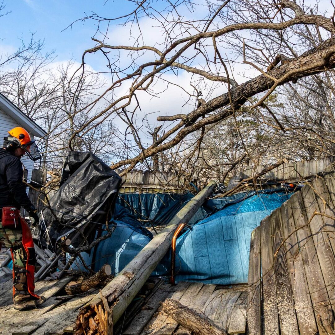
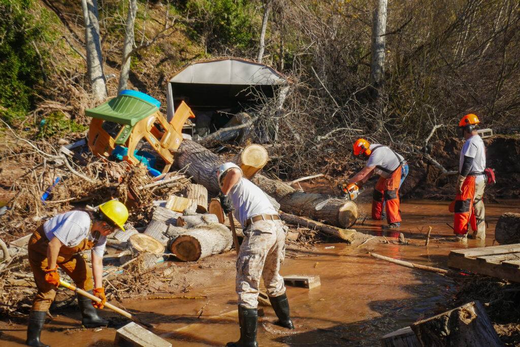
Atmospheric river flooding returned to the West Coast in 2025, when a series of atmospheric rivers hit the Pacific Northwest. Devastating damage was concentrated in Washington State, and also occurred in Montana and Oregon.
In early December, back-to-back severe storms inundated Western Washington, resulting in flooding, landslides, and dam overtopping. Several factors converged to make the atmospheric river flooding in Washington State especially severe, including the fact that the atmospheric river tapped into unusually warm Pacific moisture. Because warmer air holds more water, the system delivered higher-than-normal rainfall totals across Western Washington.

The event also followed weeks of earlier storms, meaning soils—especially in the lowlands from Seattle to Bellingham—were already saturated. With nowhere for additional water to go, runoff increased dramatically, accelerating flooding in rivers, creeks, and urban areas.
Meanwhile, in the Cascades, warmer temperatures turned what would normally be early-season snowfall into heavy rain. Here, atmospheric river flooding intensified when rain fell on a developing snowpack, melting it and sending even more water downstream. This mix of rain plus snowmelt is a classic driver of atmospheric river flooding.
Steep Terrain Intensifies Hazards
Of course, Washington’s mountainous topography played a major role. As the atmospheric river slammed into the Olympics and Cascades, the terrain squeezed out additional moisture, which not only enhanced rainfall totals but also triggered landslides, road closures, and debris flows.
Plus, all that rainfall inundated rivers—including the Skagit, Snohomish, Chehalis, and Nooksack River systems—that were already running high. With the atmospheric river pushing several inches of rain into their watersheds in just 24 to 48 hours, rapid river rises overwhelmed levees and flood defenses.
Are Atmospheric Rivers Becoming More Severe?
Scientists say yes. Climate change—specifically warming ocean and air temperatures—is increasing the moisture content of the atmosphere. That means stronger atmospheric rivers and, in many cases, more intense atmospheric river flooding.
Atmospheric river flooding is now one of the most significant drivers of disaster impacts on the West Coast. As oceans warm and storms carry more moisture, scientists warn that the most extreme atmospheric river flooding events—like those seen in California in 2024 and Washington in 2025—will continue to intensify, putting communities, infrastructure, and emergency response systems under increasing strain.